Editor’s note: Here follows the second chapter of The Story of the Malakand Field Force: An Episode of Frontier War, by Winston S. Churchill (published 1898). All spelling in the original.
(Continued from Part 1)
Chapter II: The Malakand Camps
Ibam forte via sacra. – Horace
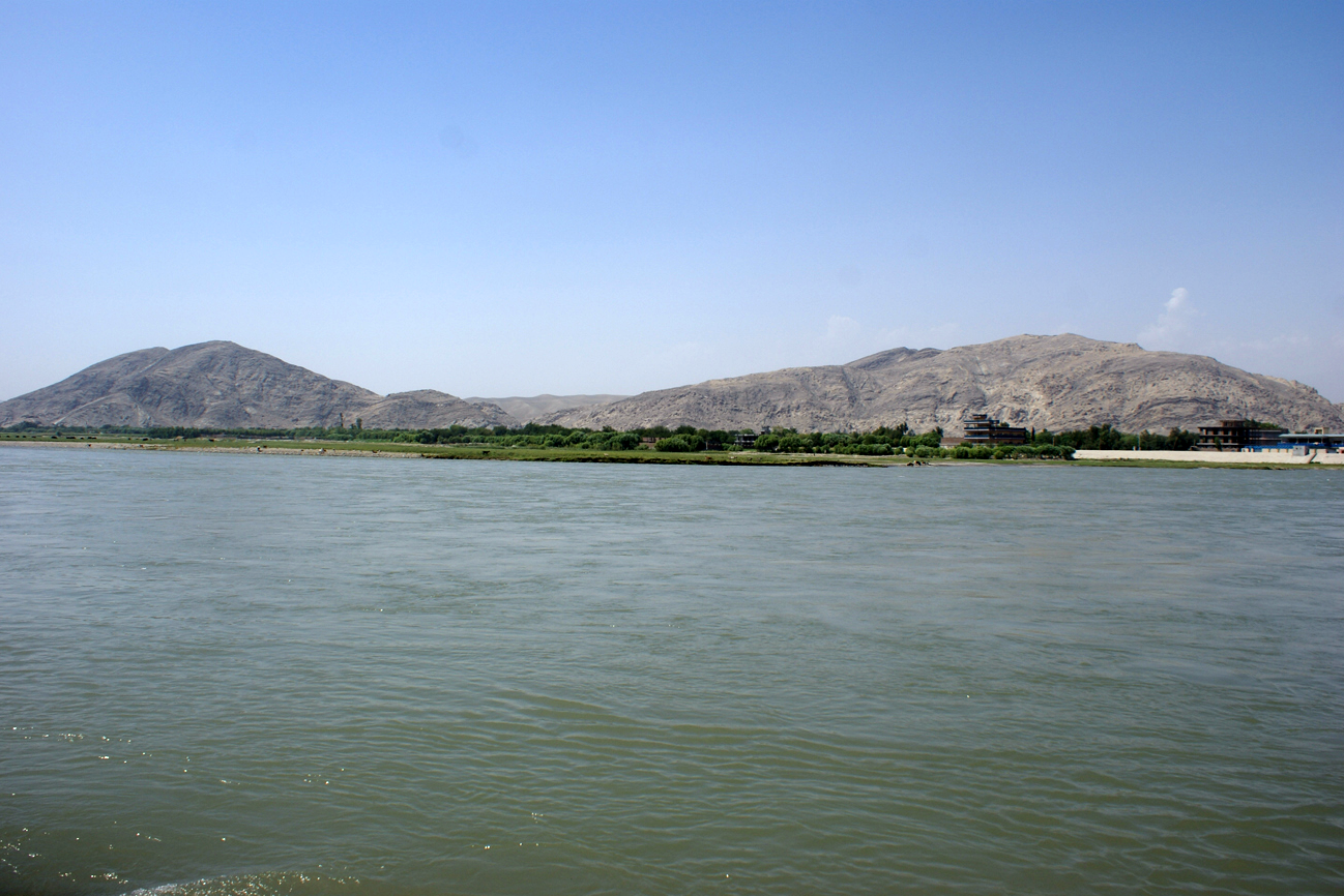
The town and cantonment of Nowshera was the base from which all the operations of the Malakand Field Force were conducted. It is situated on the India side of the Cabul River and is six hours by rail from Rawal Pindi. In times of peace its garrison consists of one native cavalry regiment, one British, and one native infantry battalion. During the war these troops were employed at the front. The barracks became great hospitals. The whole place was crowded with transport and military stores; and only a slender force remained under the orders of Colonel Schalch, the Base Commandant.
The road from Nowshera to the Malakand Pass and camps is forty-seven miles long, and divided into four stages. Usually there is an excellent tonga service, and the distance is covered in about six hours; but while the Field Force was mobilised so much traffic and so many officers passed up and down the line, that the tonga ponies were soon reduced to a terrible condition of sores and emaciation, and could hardly drag the journey out in nine, ten, or even twelve hours. After leaving Nowshera, and crossing the Cabul River, a stage of fifteen miles brings the traveller to Mardan. This place—pronounced “Merdane”—is the permanent station of the Corps of Guides. It is shady and agreeable, though terribly hot in the summer months. It boasts an excellent polo ground and a comfortable rest-house. The passer-by should pause to see the Guides’ cemetery, perhaps the only regimental cemetery in the world. To this last resting-place under the palm trees, close to the fields where they have played, and the barracks in which they lived, have been borne the bodies of successive generations of these wardens of the marches, killed in action across the frontier line. It is a green and pleasant spot. Nor is there any place in the world where a soldier might lie in braver company.
After Mardan the road becomes more dusty, and the surrounding country barren and arid. [This description applies to the autumn season. In the winter and spring the country for a time is green and the air cold.] The mountains are approached, and as the tonga advances their shapes and colours are more distinctly seen. A few knolls and ridges rising from the level plain, mark the outposts of that great array of hills. Crossing a shallow stream—a tributary of the Cabul River, Jalala, the second stage is reached. In peace time a small mud fort is the only indication, but this is expanded by the proximity of war to a considerable camp, with an entrenchment around it. Stopping only to change ponies, for it is a forsaken spot, the journey is resumed. The avenue of trees on either side has ceased. The road is seen simply as a white streak stretching towards the mountains. It is traversed in a sweltering heat and choking dust. All around the country is red, sterile and burnt up. In front the great wall of hills rises dark and ominous. At length Dargai at the foot of the pass is reached. It is another mud fort, swelled during the operations into an entrenched camp, and surrounded by a network of barbed wire entanglement. The Malakand Pass can now be seen—a great cleft in the line of mountains—and far up the gorge, the outline of the fort that guards it, is distinguishable.
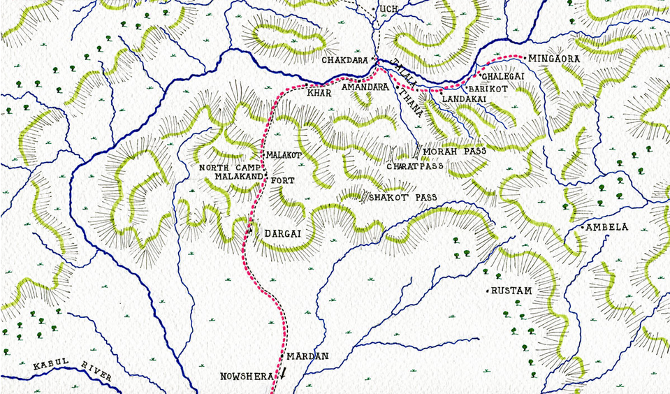
The graded road winds up, with many a turn, the long ascent from Dargai to the top of the pass. The driver flogs the wretched, sore-backed ponies tirelessly. At length the summit is neared. The view is one worth stopping to look at. Behind and below, under the haze of the heat, is the wide expanse of open country—smooth, level, stretching away to the dim horizon. The tonga turns the corner and enters a new world. A cooler breeze is blowing. A single step has led from peace to war; from civilisation to savagery; from India to the mountains. On all sides the landscape is wild and rugged. Ridge succeeds ridge. Valley opens into valley. As far as the eye can reach in every direction are ragged peaks and spurs. The country of the plains is left, and we have entered a strange land, as tangled as the maze at Hampton Court, with mountains instead of hedges. So broken and so confused is the ground, that I despair of conveying a clear impression of it.
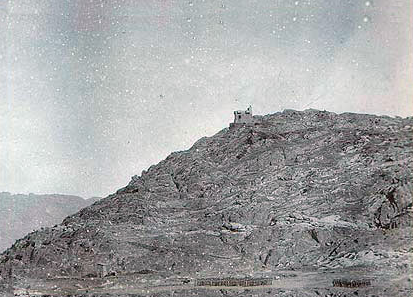
The Malakand is like a great cup, of which the rim is broken into numerous clefts and jagged points. At the bottom of this cup is the “crater” camp. The deepest cleft is the Malakand Pass. The highest of the jagged points is Guides Hill, on a spur of which the fort stands. It needs no technical knowledge to see, that to defend such a place, the rim of the cup must be held. But in the Malakand, the bottom of the cup is too small to contain the necessary garrison. The whole position is therefore, from the military point of view, bad and indefensible. In the revised and improved scheme of defence, arrangements have been made, to command the available approaches, and to block such as cannot be commanded with barbed wire entanglements and other obstructions; and by a judicious system of works much of the rim is now held. But even now I am told by competent judges that the place is a bad one for defence; that the pass could be held by the fort alone, and that the brigade stationed there would be safer and equally useful, if withdrawn to Dargai. At the time this story opens the Malakand South Camp was an impossible place to put troops in. It was easy of access. It was cramped and commanded by neighbouring heights. [Under the arrangements which have been made since the war, the Malakand position and the works at Chakdara and Dargai will be held by two battalions and some details. These will be supported by a flying column, the exact location and composition of which are as yet undetermined.]
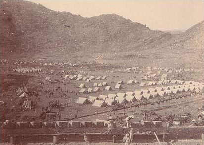
The small area of the camp on the Kotal necessitated the formation of a second encampment in the plain of Khar. This was close under the north outer edge of the cup. It was called for political reasons North Malakand. As a military position it, also, was radically bad. It was everywhere commanded, and surrounded by ravines and nullahs, which made it easy for an enemy to get in, and difficult for troops to get out. It was, of course, of no strategic value, and was merely used as a habitation for the troops intended to hold Malakand, for whom there was no room in the crater and fort. The north camp has now been definitely abandoned.
Nobody, however—least of all those who selected the site—would seem to have contemplated the possibility of an attack. Indeed the whole situation was regarded as purely temporary. The vacillation, caused by the change of parties and policies in England, led to the Malakand garrison remaining for two years in a position which could not be well defended either on paper or in reality. At first, after the Chitral campaign of 1895, it was thought that the retention of the brigade in this advanced post, was only a matter of a few weeks. But as the months passed by the camp began, in spite of the uncertainty, to assume an appearance of permanency. The officers built themselves huts and mess rooms. A good polo ground was discovered near Khar, and under careful management rapidly improved. A race-course was projected. Many officers who were married brought their wives and families to the camp among the mountains, and the whole place was rapidly becoming a regular cantonment. No cases of Ghazi outrage broke the tranquillity. The revolvers, which all persons leaving camp were by regulations obliged to take, were either unloaded or carried by a native groom. Shooting parties were organised to the hills. A well-contested polo tournament was held in Christmas week. Distinguished travellers—even a member of Parliament—visited this outpost of empire, and observed with interest the swiftness and ease with which the Anglo-Saxon adapts every situation to his sports and habits.
At the same time the station of the Malakand Brigade was far from being a comfortable one. For two years they lived under canvas or in rude huts. They were exposed to extremes of climate. They were without punkahs or ice in the hot weather. They were nearly fifty miles from the railway, and in respect of companionship and amusements were thrown entirely on their own resources. When the British cavalry officer succeeds, in spite of official opposition, expense and discouragement, in getting on service across the frontier, he is apt to look with envious eyes at the officers of the Frontier Force, who are taken as a matter of course and compelled to do by command, what he would solicit as a favour. But he must remember that this is their compensation for long months of discomfort and monotony in lonely and out-of-the-way stations, and for undergoing hardships which, though honourable and welcome in the face of the enemy, become obnoxious in times of peace.
After crossing the Malakand Pass the first turning to the right leads to the Swat Valley. The traveller is now within the mountains. In every direction the view is restricted or terminated by walls of rock. The valley itself is broad, level and fertile. The river flows swiftly through the middle. On either side of it, is a broad strip of rice fields. Other crops occupy the drier ground. Numerous villages, some of which contain large populations, are scattered about. It is a beautiful scene. The cool breezes of the mountains temper the heat of the sun. The abundant rains preserve the verdure of the earth.
In ancient times this region was the seat of a Buddhistic kingdom, and was known as Woo-Chang or “Udyana,” which means “the Park,” and proclaims the appreciation which its former possessors had of their pleasant valley. “The people,” says the Chinese pilgrim Fa-hien, who visited the country in the fifth century, “all use the language of Central India, ‘Central India’ being what we should call the ‘Middle Kingdom.’ The food and clothes of the common people are the same as in that Central Kingdom. The law of Buddha is very flourishing in Woo-Chang.” “The Park,” which includes all the country on both banks of the Swat River—then called the Subhavastu—but which perhaps applies more particularly to the upper end of the valley, was famous for its forests, flowers and fruit. But though the valley retains much of its beauty, its forests have been destroyed by the improvidence, and its flowers and fruit have declined through the ignorance, of the fierce conquerors into whose hands it fell.
The reputation which its present inhabitants enjoy is evil. Their treacherous character has distinguished them even among peoples notoriously faithless and cruel. Among Pathans it is a common saying: “Swat is heaven, but the Swatis are hell-fiends.” For many years they had lain under the stigma of cowardice, and were despised as well as distrusted by the tribes of the border; but their conduct in the recent fighting has cleared them at least from this imputation.
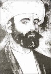
Several minor chieftains now divide authority in the Swat Valley, but till 1870 it was governed by a single ruler. The Ahkund of Swat was by origin a cowherd, an office considered most honourable in India. The cow is a sacred beast. His service is acceptable to the Gods and men. Princes glory in the name—though they do not usually carry their enthusiasm further. “Guicowar” translated literally means “cowherd.” From such employment the future Ahkund received his inspiration. He sat for many years by the banks of the Indus, and meditated. Thus he became a saint. The longer his riparian reflections were continued, the greater his sanctity became. The fame of his holiness spread throughout all the region. The Swatis besought him to come and live in their valley. After dignified and diplomatic reluctance, he consented to exchange the banks of the Indus for those of the Swat. For some years, he lived in the green valley, and enjoyed the reverence of its people. At the time of the great mutiny, Said Akbar, the King of Swat, died, and the saint succeeded to the temporal as well as the spiritual authority. In 1863 he preached the Jehad against the British, and headed the Swatis and Bunerwals in the Ambeyla campaign. The power which the Sirkar so extravagantly displayed to bring the war to an end, evidently impressed the old man, for at its close he made friends with the Government and received from them many tokens of respect.
Before he died in 1870, he summoned his people around him and declared to them that one day their valley would be the scene of a struggle between the Russians and the British. When that came to pass he charged them to fight on our side. The saying is firmly fixed in the hearts of the tribesmen, and is associated with the memory of their famous priest, known to English minds chiefly through the medium of the “Bab Ballads.”
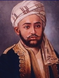
His two sons are dead, but his two grandsons, [the Mianguls of Swat] both quite young, live on in the valley, and are the owners of the Ahkund’s freeholds, which are in every section of the Swat country. They have very little political influence; but their persons and property are respected by the people and by the British for the sake of their grandfather, who sleeps in an odour of sanctity at Saidu, near Mingaora.
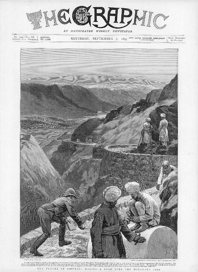
From the Malakand the signal tower of Chakdara can be seen eight miles away to the eastward. Thither the broad graded road runs like a ribbon across the plain. Seven miles from the Kotal Camp, it crosses the Amandara Pass, a gap in a considerable underfeature, which juts from the southern mountains. After this it turns more to the north and leads to the fortified bridge across the river. I invite the reader to remark this road, for it is historic. It is not only the route by which the Malakand Field Force was able to advance, but it is the very reason of their existence. Without this road there would have been no Malakand Camps, no fighting, no Malakand Field Force, no story. It is the road to Chitral.
Here then, at once, the whole vast question of frontier policy is raised. We hold the Malakand Pass to keep the Chitral road open. We keep the Chitral road open because we have retained Chitral. We retain Chitral in accordance with the “Forward Policy.” I am thus confronted at the very outset of this book, which was intended to be devoted chiefly to the narration of military events and small incidents, with that wide political question, on which the keenest intellects in England are in doubt, and the most valuable expert evidence in India is divided. The reader must not think me pusillanimous or weak if I postpone the discussion of so great and controversial a matter till a later chapter, when I may perhaps enjoy a larger measure of his sympathy and agreement. After the story has been told, it may not be inappropriate to point the moral.
Prudence encourages procrastination. But while the consideration of the advisability of the retention of Chitral may be deferred, a description of the means is convenient, if not necessary, to the present chapter.
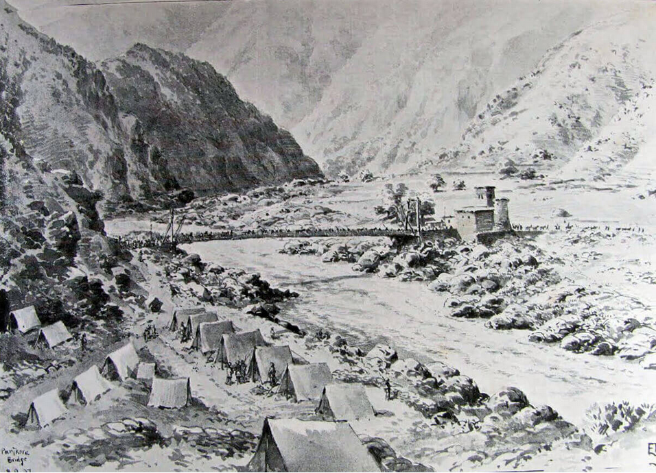
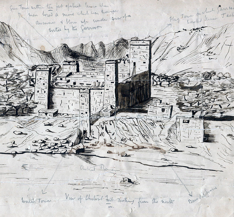
Nowshera is the railway base of the road. Thence we have followed it to Mardan and across the frontier. Here the new and disputed portion begins. Passing at first through the Lower Ranizai country, it climbs the Malakand Pass, descends into the valley beyond and runs thence through Upper Ranizai territory and Lower Swat to Chakdara. Here it crosses the Swat River by the fine suspension bridge which the fort guards. The three spans of this bridge are together nearly 1500 feet long. It was constructed in 1895, during the operations, in about six weeks, and is a very remarkable piece of military engineering. Beyond the Swat the road runs through the territories of the Khan of Dir, north and east to Sadu, an obscure village thirty-five miles from Malakand. This marks the end of the first section, and further than this wheeled traffic cannot go. The road, now become a camel track, winds along the left bank of the Panjkora River to within five miles of Dir, where it crosses to the right bank by another suspension bridge. Thence it continues to the junction of the Dir stream, along which it finds its way to Dir itself, some fifty miles from Sadu. Beyond Dir camels cannot proceed, and here begins the third section—a path practicable only for mules, and about sixty miles long. From Dir the road is a triumph of engineering. In many places it is carried on wooden galleries perched on the faces of steep and tremendous cliffs, and at others it works round spurs by astounding zig-zags, or is scarped from the mountain side. At the end of the road is Fort Chitral with a garrison of two battalions, one company of sappers, and two mountain guns.
The road is maintained and protected by the tribes through whose territories it passes; but the two principal points where it might be closed are held by Imperial garrisons. The Malakand Fort guards the passage of the mountains. Chakdara holds the bridge across the river. The rest is left to the tribal levies. The Ranizai tribe receive an annual subsidy from the Indian Government of 30,000 rupees, out of which they maintain 200 irregulars armed with Sniders, and irreverently called by the British officers, “Catch-’em-alive-Os.” These drive away marauders and discourage outrage and murder. The Khan of Dir, through whose territory the road runs for seventy-three miles, also receives a subsidy from Government of 60,000 rupees, in consideration of which he provides 400 irregulars for its service.
Until the great rising these arrangements worked admirably. The tribesmen interested in the maintenance of the route, were most reluctant to engage in hostilities against the Government. The Lower Ranizais, south of Malakand, abstained altogether. The elders of the tribe collected all the arms of their hot-headed youths, and forbade them to attack the troops. The Upper Ranizais were nearer the scene of the disturbance, and were induced by superstition and fear to join the Mullah; but very half-heartedly. The Swatis were carried away by fanaticism. The Khan of Dir throughout behaved loyally, as he is entirely dependent on British support, and his people realise the advantages of the subsidy.
If the road is interesting its story is more so, and a summary of the events and causes which have led to its construction, may also throw some light on the political history and methods of the border tribes.
The uncertainty and insecurity of their power, has always led petty chiefs to seek the support of some powerful suzerain. In 1876 the Mehtar of Chitral, Aman-ul-Mulk, was encouraged to seek the protection, and become the vassal of our vassal, the Maharaja of Cashmere. In accordance with the general scheme of advance, then already adopted by the Indian Government, a British agency was at once established at Gilgit on the Chitral-Cashmere frontier. Aman-ul-Mulk was presented with a certain supply of arms and ammunition, and an annual subsidy of 6000 rupees, afterwards raised to 12,000 rupees. The British thus obtained an interest in Chitral, and a point of observation on its borders. In 1881 the agency was withdrawn, but the influence remained, and in 1889 it was re-established with a much larger garrison. Meanwhile Aman-ul-Mulk ruled in Chitral, showing great respect to the wishes of the Government, and in the enjoyment of his subsidy and comparative peace. But in 1892 he died, leaving many sons, all equally ferocious, ambitious and unscrupulous. One of these, Afzal by name, though not the eldest or acknowledged heir, had the good fortune to be on the spot. He seized the reins of power, and having murdered as many if his brothers as he could catch, proclaimed himself Mehtar, and invited the recognition of the Indian Government. He was acknowledged chief, as he seemed to be “a man of courage and determination,” and his rule afforded a prospect of settled government. Surviving brothers fled to neighbouring states.
Nizam, the eldest, came to Gilgit and appealed to the British. He got no help. The blessing had already been bestowed. But in November, 1892, Sher Afzul, a brother of the late Aman, returned by stealth to Chitral, whence fraternal affection had driven him, and killed the new Mehtar and another brother, both of whom were his nephews. The “wicked uncle” then ascended the throne, or its equivalent. He was, however, opposed. The Indian Government refused to recognise him. Nizam, at Gilgit, urged his claims, and was finally allowed to go and try to regain his inheritance. The moral support of 250 Cashmere rifles brought him many adherents. He was joined by the people. It was the landing of William of Orange on a reduced scale, and with Cashmere troops instead of Dutch Guards. Twelve hundred men sent by Sher Afzul to oppose him, deserted to his side. The avuncular usurper, realising that it might be dangerous to wait longer, fled to Afghanistan, as James II had fled to France, was received by the ruler with hospitality, and carefully preserved as an element of future disorder.
Nizam now became Mehtar according to his desire. But he did not greatly enjoy his power, and may have evolved some trite reflections on the vanity of earthly ambition. From the first he was poor and unpopular. With the support of the Government of India, however, he managed to maintain a weak, squalid rule for a space. To give him countenance, and in accordance with the Policy, Captain Younghusband was sent to the country with a hundred bayonets. The Gilgit garrison was increased by a battalion, and several posts were established between that place and Mastuj.
Thus the Imperial forces had entered Chitral. Their position was soon to become one of danger. They were separated from Gilgit by many miles of bad road, and warlike tribesmen. To move troops from Gilgit would always be slow and difficult. Another route was however possible, the route I have described—a route northwards from Peshawar through Dir—shorter and easier, starting from British territory and the railway. Towards this line of communication the Indian Government now looked. If British troops or agents were to be retained in Chitral, if in other words their recognised policy was to be continued, this route must be opened up. They sounded the Home Government. Lord Kimberley replied, deprecating increase of responsibilities, of territory and expenditure, and declining to pledge himself to support such a scheme. At the same time he sanctioned the temporary retention of the troops, and the agent, in the hopes of strengthening Nizam. [Despatch from Secretary of State, No.34, 1st Sept., 1893.]
At this point Umra Khan must enter the story. The Gilgit agency report, dated 28th April, 1890, speaks of this chief, who was the Khan of Jandul, but whose influence pervaded the whole of Bajaur as “the most important man between Chitral and Pashawar.” To this powerful ruler, another of the sons of Aman, named Amir, had fled from the family massacre which followed his father’s death. Umra Khan protected him and determined to turn him to his own advantage. In May, 1894, this youth—he was about twenty years of age—returned to Chitral, professing to have escaped from the hands of Umra Khan. He was kindly received by Nizam, who seems to have been much hampered throughout his career by his virtue. On 1st January, 1895, Amir availed himself of his welcome, to murder his brother, and the principal members of the Chitral Cabinet. He proclaimed himself Mentar and asked for recognition. The Imperial officers, though used to frontier politics, refused to commit themselves to any arrangement with such a villain, until the matter had been considered in India.
Umra Khan now advanced with a large force to the head of the Chitral Valley, nominally to assist his dear friend and ally, Amir, to consolidate his rule, really in the hopes of extending his own territories. But Amir, knowing Umra well, and having won his kingdom, did not desire to share it. Fighting ensued. The Chitrals were beaten. As he could not make any use of Amir, Umra Khan invited the wicked uncle to return. Sher Afzul accepted. A bargain was struck. Sher Afzul claimed to be made Mehtar, Umra supported his claims. Both threatened force in the event of opposition.
But the Imperial Government rose in wrath, refused to have anything to do with the new claimant, informed him that his language was impertinent, and warned Umra Khan to leave Chitral territory forthwith or take the consequences. The answer was war. The scanty garrisons and scattered parties of British troops were attacked. A company of the 14th Sikhs was cut to pieces. Lieutenants Fowler and Edwards were taken prisoners. Fort Chitral, into which the rest of the Chitral mission and their escort had thrown themselves, was closely and fiercely besieged. To rescue them was imperative. The 1st Division of the Field Army was mobilised. A force of nearly 16,000 men crossed the frontier on the 1st April, from Mardan, to advance to the relief by the shortest route—the route through Swat and Dir—the line of the present Chitral road. The command of the expedition was confided to Sir Robert Low. Sir Bindon Blood was Chief of the Staff.
So far the tale has been of the steady increase of British influence, in accordance with an avowed and consistent policy—primarily in Chitral, and ultimately throughout the border tribes. One movement has been followed by another. All have been aimed at a common end. Now suddenly we are confronted with an act by which the Government of India with open eyes placed an obstacle in the path, which they had so long pursued, to follow which they had made so many efforts themselves and demanded so many sacrifices from their subjects. Perhaps from compunction, but probably to soothe the Liberal Government, by appearing to localise the disturbances, and disclaiming any further acquisition of territory, they issued a proclamation to “all the people of Swat and the people of Bajaur, who do not side with Umra Khan,” in which they declared that they had “no intention of permanently occupying any territory through which Umra Khan’s misconduct” might “force them to pass, or of interfering with the independence of the tribes.” [Proclamation, 14th March, 1895.]
If this proclamation was intended for political purposes in England, it, from one point of view, succeeded most admirably, for there has been nearly as much written about it as about all the soldiers who have been killed and wounded in the war. It had, however, no effect upon the tribesmen, who were infuriated by the sight if the troops and paid no attention to the protestations of the Government. Had they watched with care the long, steady, deliberate advance, which I have so briefly summarised; had they read the avowed and recorded determination of the Indian Administration “to extend and, by degrees, to consolidate their influence” [Letter from Government of India, No.407, 28th February, 1879.] in the whole drainage system of the Indus, they might have even doubted their sincerity. Instead, and being unable to make fine distinctions, they saw only invasion in the military movements.

They gathered accordingly, to oppose the advance of the troops. To the number of 12,000 they occupied the Malakand Pass—a tremendous position. From this they were driven with great slaughter on the 3rd of April, by the two leading brigades of Sir Robert Low’s force. Further operations resulted in the passage of the Swat and Panjkora Rivers being effected. The road to Chitral was open. The besiegers of the fort fled, and a small relieving force was able to push through from Gilgit under Colonel Kelly. Umra Khan fled to Afghanistan, and the question of future policy came before the Government of India.
Two alternatives presented themselves: either they must “abandon the attempt to keep up any effective control” over Chitral, or they must put a sufficient garrison there. In pursuance of their recognised policy, the Council decided unanimously that to maintain British influence in Chitral was “a matter of first importance.” In a despatch [Despatch of Government of India, No.240, 8th May, 1895.] to the Home Government they set forth all their reasons, and at the same time declared that it was impossible to garrison Chitral without keeping up the road from Peshawar, by which the Relief force had advanced.
On the 13th of June Lord Rosebery’s Cabinet replied decisively, with courage if not with wisdom, that “no military force or European agent should be kept at Chitral, that Chitral should not be fortified, and that no road should be made between Peshawar and Chitral.” By this they definitely and finally repudiated the policy which had been consistently followed since 1876. They left Chitral to stew in its own juice. They over-ruled the Government of India. It was a bold and desperate attempt to return to the old frontier line. The Indian Government replied: “We deeply regret but loyally accept decision,” and began to gather up the severed strings of their policy and weave another web.
But in the nick of time the Liberal Administration fell, and Lord Salisbury’s Cabinet reversed their decision. It is interesting, in reading the Blue Books on Indian questions, to watch the emotions of party principles, stirring beneath the uniform mask of official responsibility—which the most reckless of men are compelled to wear as soon as they become ministers. The language, the style, the tone of the correspondence is the same. It is always a great people addressing and instructing their pro-consuls and administrators. But the influence inclines backwards and forwards as the pendulum of politics swings. And as the swing in 1895 was a very great one, a proportionate impulse was given to the policy of advance. “It seemed” to the new ministry “that the policy… continuously pursued by successive Governments ought not to be lightly abandoned unless its maintenance had become clearly impossible.” [Despatch, Secretary of State, No.30, 16th Aug., 1895.] Thus the retention of Chitral was sanctioned, and the road which that retention necessitated was completed.
I approach with nervousness so great a matter as the “Breach of Faith” question. In a book devoted chiefly to the deeds of soldiers it seems almost presumptuous to discuss an affair which involves the political honour of statesmen. In their unnecessary and gratuitous proclamation the Government of India declared, that they had no intention of interfering with the tribes, or of permanently occupying any territory, the troops might march through; whereas now they do interfere with the tribesmen, and have established garrisons at Dargai, Malakand and Chakdara, all of which are in the territory through which the troops passed. But it takes two to make a bargain or a breach of faith. The tribes took no notice of the proclamation. They did not understand it. They did not believe it. Where there is no faith there can be no breach of faith. The border peoples resisted the advance. That position annulled the proclamation, and proved that it was not credited by the tribesmen. They do not think they have been tricked. They do not regard the road as a “breach of faith.” What they do regard it as, is a menace to their independence, and a prelude to annexation. Nor are they wrong. Looking at the road, as I have seen it, and have tried to describe it, running broad and white across the valley; at the soldiers moving along it; at the political officers extending their influence in all directions; at the bridge and fort of Chakdara; and at the growing cantonment on the Malakand Pass, it needs no education to appreciate its significance. Nor can any sophistry obscure it.