
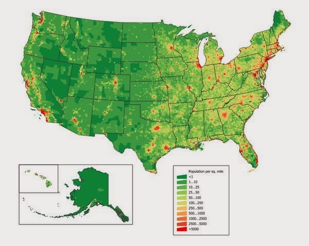
In Where to Live Part I we took a look at a green and red map that was almost the inverse of this one – that of annual rainfall. In this map, which shows USA population per square mile, the red areas are the most populous and the green areas the least so. What was ‘high’ on the other map is ‘low’ on this one, generally. That the maps share similarities should not be all that much a of surprise, really. Plenteous rainfall means abundant water for people and crops, and people and crops together will usually develop a larger population density over time.*
That creates something of a dichotomy for the prepper. The existence of a lot of people in one place is evidence that it’s easier to live there than in a place where almost no one lives. More people live in Alabama than Alaska for that very reason. On the flip side, in most SHTF scenarios population density is the enemy: you can squirrel away enough for yourself and your family, raise your food, filter your water, work with your tools, but if you are surrounded by millions of people who also need to eat, who also have guns, and who are more desperate and scared than you, then you are not in a place conducive to long-term survival.** Like Joel Skousen once said of living in a nuclear blast zone: don’t build a better bunker, move!
Not only is local population density an immediate threat, population movements following an event can also cause problems. For example, when Hurricane Katrina emptied New Orleans, the folks who fled brought trouble as far away as Houston. So a realistic threat assessment will not only take account of where populations are, but where they will go and by what means. You may live 100 miles from Chicago, but if you live a mile from the interstate, plenty of Chicago can visit you in 2 hours, at least until the roads clog. In the case of Katrina, a relatively small geographical area was impacted, that of the Gulf Coast near New Orleans. But what if the area impacted includes a dozen cities? A hundred? Are you in a position where you’ll be quickly overrun by hungry, scared, desperate refugees?
On the other hand, I am absolutely convinced that the opposite is also a problem: being holed up in a cabin where you are the only family for 20 miles merely presents a different set of challenges. What do you do for a child with a burst appendix? What do you do when a gang of armed men arrives on horseback? Who do your kids marry? The idea of bugging out into nowhere and living in a log cabin near a clear mountain pool is idyllic, but there’s a reason no one really does it. At least not for long.
Obviously an individual’s choice of location will be a balance of both extremes and many factors (most of which I hope to cover in time). If you’re a highly-paid technical professional, you probably need to live within driving distance of a red spot, because that’s where the highly-paid technical jobs are. If you live far from the city but have to commute, you’ll probably live near a highway to avoid spending an extra hour or two a day driving. If you live in the middle of nowhere, you probably are more reliant on the petroleum market than you realize, not only to get to the store, but for truckers to get the stuff you need to that store. Both near and far have tradeoffs that must be weighed.
Best places: Western US at least 100 miles from the Pacific coast, northern Maine and New York, upper Michigan.
Marginal places: Rural areas east of the Mississippi, western Oregon.
Worst places: Urban areas, both coasts, and on interstates between urban areas, especially in the NY-Washington DC corridor and the LA-San Diego corridor.
For my own part, I live about a mile from a US highway, 25 miles from work, and 100 miles from the nearest red spot. It’s both close enough and far enough for me. For others, based on their own threat assessments and living preferences, that might be dangerously close or insufferably isolated.
* Obviously, other factors factor into what the map shows. People congregate around ports and the East Coast is the oldest and most immigrated-to area of the country. Many immigrants simply stayed in the port through which they arrived and never planted a single ear of corn.
** Unless you can set yourself up quickly as a regional warlord. Maybe a post on that will be in order later.
Where to Live II – Population Density
4 Comments Leave a Reply
Leave a Reply
Support Men Of The West


Latest from Family

The Most Wonderful Time of the Year
Christmas has come again. It is our yearly reminder that even though the world is still a dangerous and uncertain place that God has not forgotten or forsaken us. I think I

“Joseph” by Charles Kingsley
Editor’s note: The following is extracted from The Works of Charles Kingsley, Vol. 25 (published 1885). (Preached on the Sunday before the Wedding of the Prince of Wales. March 8th, third Sunday
Fly, Fly Dear Friend
It is with heavy heart that we report that our good friend and MOTW Poet Laureate, Ian McLeod, has passed away. He was too young, and he will be dearly missed. Offer
You Can’t Have Both Feminism and Chivalry
If women are not weaker than men there is zero reason to “protect” or “let them go first” or “open the door for them.” Now because I’m dead set against feminism, I

A Place for Everyone
If you ever played any team sports, you’ll be familiar with motivational quotes. Successories kicked things off in 1985 as a catalog company. There are entire campaigns and web sites devoted to
“Worst places: Urban areas, both coasts”
Boat.
Truth. I might one day explain how terrible and awful and horrible the idea of a bugout boat is.
5
4.5